The flood that built the dam.
For two days at the end of February 1938, a pair of Pacific storms sat over the San Gabriel Mountains and dropped more than 32 inches of rain — roughly a year's worth of precipitation — into the watersheds above Los Angeles. When the levees on the Tujunga Wash failed, the flood killed at least 115 people across the metropolitan area. Two years later, Hansen Dam was finished.
February 27 – March 3, 1938
Los Angeles is a desert city with a serious rainfall problem. The problem is not volume; the problem is intensity. Most years the mountains see twelve to fifteen inches of rain, politely distributed across the winter months. Every few decades, the sky opens, and an entire year's worth arrives in a single week.
That is what happened in late February and early March of 1938. Two successive storm systems delivered more than 32 inches of rain to the higher elevations of the San Gabriel Mountains over the course of about five days. The soils were already saturated from earlier storms. Every watershed flowing off the mountains into the San Fernando Valley overflowed its channels at once. The Tujunga Wash levees — where Big Tujunga Wash and Little Tujunga Wash converge just north of what would become Hansen Dam — gave way. The Los Angeles River hit a peak discharge of 99,000 cubic feet per second, ten times its normal flood stage.
Across the metropolitan region, at least 115 people died (later estimates put the figure as high as 144). Seventy-seven bridges were destroyed. Property damage was estimated at $78 million in 1938 dollars — more than $1.7 billion in modern terms. The eastern San Fernando Valley, downstream of the Tujunga drainage, was among the hardest-hit areas.
Federal response
The 1938 flood was the event that pushed Southern California flood-control policy from local to federal. The Los Angeles County Flood Control District had been established in 1915 after an earlier flood; taxpayers had approved bond measures in 1917 and 1924; but the scale of infrastructure required to actually channelize the region's rivers was beyond local financing. After 1938, federal assistance was requested and granted.
The U.S. Army Corps of Engineers, Los Angeles District, took the lead. The Corps began a multi-decade program to channelize the Los Angeles River, Tujunga Wash, Big Tujunga Wash, Little Tujunga Wash, Pacoima Wash, and essentially every other major drainage in the basin. The plan required strategic flood-control dams at the heads of the major watersheds — dams that would not generate power or store drinking water, but would catch floodwater and release it slowly during and after storm events.
Hansen Dam, 1939 – 1940
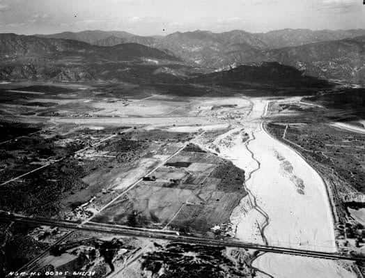
Aerial view of the Hansen Dam construction site, June 1939 — the Tujunga Wash flood plain a year before the dam's completion, with the San Gabriel Mountains behind.
Photograph · U.S. Army Corps of Engineers
The Corps began construction on what would become Hansen Dam in September 1939. The site was on Tujunga Wash, about a mile downstream of the confluence of Big Tujunga and Little Tujunga Washes, and about four miles southeast of the city of San Fernando. To acquire the site, the Corps purchased the horse ranch of Homer and Marie Hansen, who had established their operation on this land back in the 19th century. The dam carries the Hansen name.
At the time of its completion in September 1940, Hansen Dam was the largest earthen flood-control dam of its type in the world. Its horseshoe-shaped embankment runs roughly 3.2 kilometers (two miles) long, nine meters wide, and 30 meters (97 feet) high above the original streambed. The construction workforce numbered nearly 1,000 men, supervised by the San Francisco general contractor Guy F. Atkinson Co. The final cost exceeded $11 million in 1940 dollars.
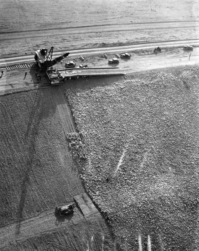
How Hansen Dam was built, 1940. A six-inch layer of gravel was spread over the earth (left), followed by a thick layer of rock (right) — dumped by a 30-ton truck lowered onto the fill by derrick from the ramp at top.
Herald Examiner Collection · Los Angeles Public Library (TESSA)
In conjunction with Sepulveda Dam (completed 1941) and Lopez Dam, Hansen Dam is vital for the flood control protection of the lower portions of the San Fernando Valley and the City of Los Angeles.
How it works
Hansen Dam is a dry dam. Most of the year it holds no water at all; the Tujunga Wash flows through outlet works at the base of the embankment and continues downstream. During heavy storms, the dam catches incoming runoff in the flood control basin behind it — a 1,300-acre reservoir that fills temporarily and then drains through controlled outlet gates over hours or days, so that the downstream channels never see flood peaks they cannot carry.
The basin behind the dam has, over the decades, accumulated debris from every major storm since 1940. In 1981 the Corps proposed raising the height of the dam rather than paying the enormous cost of excavating the sediment. That proposal did not pass; the Corps now excavates sediment periodically to maintain storage capacity.
A recreation area, too
By the mid-1940s, the basin behind Hansen Dam was already drawing recreational visitors. In 1952, the Los Angeles County Department of Parks and Recreation opened Holiday Lake in the basin — a permanent water body used for swimming, boating, and fishing. Holiday Lake persisted for about forty years before filling with sediment and being abandoned in 1991.
Today the basin is the Hansen Dam Recreation Center, with golf courses, ball fields, fishing ponds, hiking and equestrian trails, and a County-managed wildlife habitat along the Big Tujunga Wash behind the dam. During heavy rain events, the recreational facilities are closed and the basin reverts to its design function: catching flood water that would otherwise roll into Sun Valley, Pacoima, North Hollywood, and the Los Angeles River corridor.
Why this matters to La Tuna Canyon
La Tuna Canyon sits in the Verdugo foothills directly above the drainages that feed into the Tujunga Wash system. Without Hansen Dam (and Sepulveda Dam downstream of it), the canyon's outflow — and the runoff from every major storm cycle — would pile up at the bottom of the Valley in uncontrolled flood stages. Every major storm since 1940 that did not produce an eastern-Valley flood disaster is, in large part, the work of this dam.